Showing posts with label display. Show all posts

Wednesday, February 05, 2014

Senior Art --- Ceramics Exhibit Announcement

The Armacost Library is pleased to host it's second annual Senior Art Exhibition.


The Ceramics works of Antonio Argenis Gutierrez '14 are displayed throughout the second floor lobby area of the library. You may view these one of a kind ceramic pieces during regular library hoursThis Senior Art Exhibition is scheduled to run from Friday, January 31 to Tuesday, March 11, 2014.


An Artist's Reception will be held in the Armacost Library on Friday, February 7 from 3:00-5:00 p.m.


Please contact Antonio at Antoniogutierrez50@gmail.com if you are interested in purchasing an item.

A price list is available at the library One-Stop Desk.


Wednesday, October 09, 2013

The Magic of Redlands! Homecoming 2013


This year at Homecoming, be sure to stop by at the Magic of Redlands Magic Show! Featured, will be award-winning magicians such as Tina Lenert, Rob Zabrecky, and several others.The show will take place in the University of Redlands Memorial Chapel on Friday, October 18, 2013 from 8:00-9:30 p.m.


Tina Lenert http://www.mcmagicwords.com 
Rob Zabrecky http://www.robzabrecky.com/index.html

For more information on The Magic of Redlands Magic Show and all of the other activities going down during Homecoming weekend, visit the Alumni Page.

Come visit the second floor lobby of the Armacost Library to enjoy the Magic of Redlands Homecoming 2013 display!

Zack Schrimpf

Thursday, January 31, 2013

Armacost Library: More Than Just Books!


Image of students studying at Armacost LibraryI’ve worked here in the Library for four years now. In that time, I have discovered there is more to a library than just books.  

Sure, patrons come in to check out books, search our wide array of databases, and get research help.  But they also come in to see our beautiful displays in the lobby that continually change and  show everything from student art, upcoming library events, local history, and other aspects of campus life you might not be aware of.  Our study lounges are inviting and conducive to learning and collaboration.  If you're looking for quiet and a space to de-stress, we have those too.  


Image of Sandi Richey with student at circulation desk
And then there’s our wonderful staff,  always available and always happy to help.  Whether you need a library card, help locating materials, or have questions about anything in the library or on campus, our staff is here to help. 

Debbie Alban
Administrative Assistant
Armacost Library, University of Redlands
x8092

Thursday, November 15, 2012

Telling Stories With Maps

Previously we talked about the storytelling power of print maps. The map displays at Armacost Library and A.K. Smiley Public Library highlight some ways print maps can be an important part of storytelling. Using web-based digital maps to bring a tale to life is yet another powerful way to infuse geography into a narrative. The use of both print and web-based maps are just some of the tools available to students, faculty, staff, and administrators at University of Redlands. Maps, whether printed or web-based, are basic spatial information that are important elements of map-based storytelling.

Telling stories with maps is a great way to "better understand the interconnectedness that makes the world work" and help story-map creators, users, and viewers "become better world citizens" (Esri, Telling Stories With Maps: A White Paper, February 2012).

Story maps can have various purposes. Still, all share general elements and principles that include a simple, clear message, spatial information, and user experience. Below is an example of a story map that gives us a picture of the 2008 presidential election. The story map invites users to consider the past as a means to think about the future. It also melds data based on location with information based on individual and group behavior and categories. The story map also invites us to interact, learn, and explore. Even ask questions.

image of the interactive online map of the 2008 presidential election results by precinct
Past As Prologue? 2008 Presidential Election Results By Precinct
A story map powered by Esri


Wednesday, November 14, 2012

November 14 is GIS Day 2012


Geography and spatial skills help us see the world in different ways. GIS (geographic information systems) allow us to make connections and see novel, even unexpected, patterns from well-known, commonplace information. Esri's Matt Artz blogs, "With GIS we are not simply replacing paper-and-ink-based maps with maps on computer screens, but we are evolving and extending the definition of what 'maps' are and how we use and interact with them."

On GIS Day, November 14, 2012, presenters from different organizations within and around Redlands, California will talk about GIS and its uses in different contexts. All presentations will be held in A.K. Smiley Public Library's Assembly Room, starting at 3 p.m. From 5 to 5:30 p.m., David Smith, University of Redlands' GIS and Mapping Consultant, will speak about the uses of GIS technology on campus for classroom teaching, research, and practical projects. Students from the University of Redlands MS GIS program will also be available to provide information.

Tuesday, November 13, 2012

Maps Tell Stories

When we think of maps, we are often confronted with many questions. One of the most common is: "What is the map of?" Such a simple question. Or so it seems.

In our quest to understand what we are looking at, we are taken by the simplicity of maps. We overlook that maps, as Esri's Matt Artz stated, "are abstractions of geography." They focus information and communicate complex matters succinctly and easily. Within the finite border of a paper map, elaborate concepts can disappear to allow us to make use of the information it provides.

Sometimes the stories maps tell are obvious. 
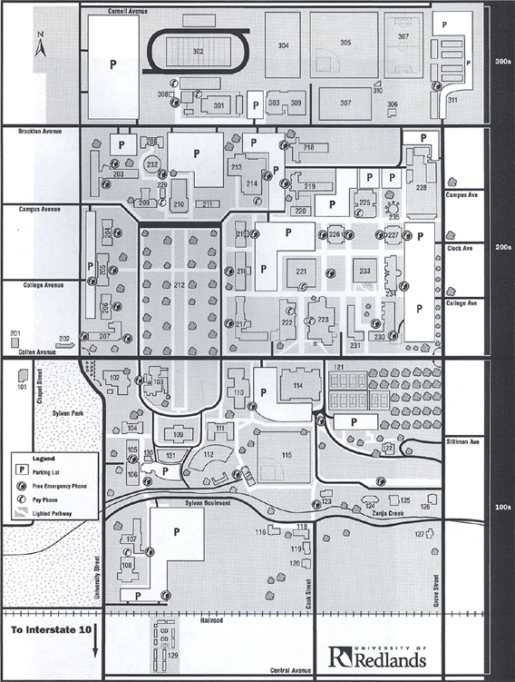
A map of the University of Redlands campus, for example, tells a viewer what the most valuable pieces of information are. Because of this, we can logically assume that the campus map is geared towards people who need to know where to park their vehicle and are concerned about safety while on campus.

Other times, the stories maps tell may not be readily evident. A bird's eye view map of the City of Redlands from 1888, courtesy of the Redlands Area Historical Society, for instance, may provide stories that may not resonate with viewers from 2012.

Until a map is placed in context with other information-bearing objects, such as books, other maps, pictures, films, poems, or letters, the ability of maps to tell stories can go unnoticed.

Armacost Library's Geography Awareness Week displays highlight the ability of maps to tell stories. To help library visitors and patrons understand the storytelling power of print maps, we created a brochure that stresses the links between written works and the geographic information they contain. By pairing maps with books and images, we are calling attention to the importance of place and location in history, fiction, cultures, and art.

The Geography Awareness Week brochures, along with the University of Redlands Armacost Library and the A.K. Smiley Public Library map displays, are part of the GIS Day community events in Redlands, California.

Inside panel of Armacost Library's Geography Awareness Week brochure

Monday, November 12, 2012

Maps on Display at Armacost Library

As a companion to the A.K. Smiley Public Library display, a sister exhibit at Armacost Library was created by Armacost Library GIS and maps intern Stephanie Milner and outreach librarian Melissa Cardenas-Dow. Like the display at A.K. Smiley, the Armacost Library layout featured images of maps and books. This time, they are all from Armacost Library's collections.

Armacost Library's display also focuses on local, historic California. The exhibit's focal map is one that depicts the Salton Sea. It is paired with a copy of Marine Geology of the Gulf of California, edited by Tjeerd Van Andel  (1964). Photos of a map of Redlands from 1957 is paired with Redlands, Our Town by Frank E. Moore, with sketches by Jeff Owens (1984). A map of the city of Riverside is matched with a working paper from 1991, The National Orange Company Packing House: An Architectural and Technological History, 1898-1940 by Ronald Tobey, Charles Wetherell, Kevin Hallaran, and Buffie Hollis, published the University of California Riverside Department of History. Images of a map of Carmel-by-the-Sea accompanies the text Cruising With Robert Louis Stevenson: Travel, Narrative, and the Colonial Body by Oliver S. Buckton (2007). Pictures of a map of the territories of Gabrielino tribes correspond with O, My Ancestor: Recognition and Renewal for the Gabrielino-Tongva People of the Los Angeles Area by Claudia Jurmain and William McCawley (2009) and Tovangar (World): A Gabrielino Word Book by Anne Galloway (1978). The San Bernardinos: The Mountain Country From Cajon Pass to Oak Glen, Two Centuries of Changing Use by John W. Robinson (1989) is paired with a map showing routes from the Orange Belt cities in Southern California to the San Bernardino mountain resorts.

Geography Awareness Week 2012 display sign at
Armacost Library, University of Redlands
and A.K. Smiley Public Library

Geography Awareness Week 2012 display
at Armacost Library, University of Redlands


Highlighting the historical, artistic, and narrative significance of maps and map-making are the signs Stephanie Milner created to draw library visitors to the 2012 Geography Awareness Week displays. The display sign has two bird's eye view images of historic Los Angeles, California. The top image is a view of the city from 1877. The bottom image is from 1909. Both images came from the Library of Congress digital collections.

University of Redlands Armacost Library's Irvine Map Collection is currently being reorganized. Maps from the collection are still available for viewing and study upon request.

The University of Redlands Armacost Library map display, and its sister exhibit at A.K. Smiley Public Library, are part of the GIS Day community events in Redlands, California.

Sunday, November 11, 2012

Armacost Library Display at A.K. Smiley Public Library

In preparation for Geography Awareness Week, Armacost Library's GIS and maps intern Stephanie Milner and outreach librarian Melissa Cardenas-Dow erected a small display of maps and images highlighting the storytelling power of maps. The display features images of maps from Armacost Library that are significant to books available at A.K. Smiley Public Library.


picture of display of images of associated maps and books at A.K. Smiley commemorating Geography Awareness Week 2012
Geography Awareness Week 2012 display
at A.K. Smiley Public Library
The entire display consists of images of maps and books that show the historical past of California. In the middle of the display is a bridle trail map of Redlands from 1941. This map, from A.K. Smiley's Heritage Room collection, depicts different trails in and around the city of Redlands. Many of the trails have been used for centuries. Some are now part of private property and are closed to the public. Others are part of the Redlands Conservancy's Heritage Trails Project, which preserves and maintains historic rural spaces in Redlands for city residents and visitors to enjoy.

Surrounding the bridle trail map from A.K. Smiley's Heritage Room are images of maps from University of Redlands, Armacost Library's Irvine Map Collection. All are paired with books from A.K. Smiley's circulating collection.

A City of Redlands map from 1957 brings geographical context to Redlands Remembered: Stories From the Jewel of the Inland Empire by Joan Hedges McCall (2012). A map of the territories of Gabrielino and adjoining Native American tribes complements The First Angelinos: The Gabrielino Indians of Los Angeles by William McCauley (1996). A map of Carmel-by-the-Sea, a small city in the Monterey Peninsula of central California, is paired with Robert Louis Stevenson's 1883 novel Treasure Island. The real-life California coastal location has long been lauded as the inspiration for Stevenson's book. The Elephant Quilt: Stitch by Stitch to California! by Susan Lowell and Stacey Dressen-McQueen (2008), a tale chronicling young Lily Rose's journey from Missouri to California, is supported by images of an 1861 map of Missouri and a 1954 map of California.

University of Redlands Armacost Library's Irvine Map Collection is currently being reorganized. Upon request, maps in the collection are still available for viewing and study.

The A.K. Smiley Public Library map display, and its sister display located at University of Redlands Armacost Library, are part of the GIS Day community events in Redlands, California.

Wednesday, November 02, 2011

Art @ Armacost Library: Introduction to Sculpture


Armacost Library is very happy to have student art work showcased in our lobby's display areas! Thanks go out to Professor Renee Azenaro's fall 2011 course, Introduction to Sculpture, for loaning us their wonderful pieces. The image shown on this blog does not do the work justice.

The sculpture pieces may be viewed during the hours Armacost Library is open. The pieces will be up for viewing from now till the end of November.

The students and Professor Azenaro will also be holding an art show reception on Tuesday, November 8, 2011, from 9:30 to 11:30 a.m. Light refreshments will be provided.